
Over Half Next Generation Muni Shelter Displays Installed with More Upgrades Coming

Over Half Next Generation Muni Shelter Displays Installed with More Upgrades Coming
By Kharima Mohamed

New Muni information screen at a bus shelter above Muni system map. New Muni service information displays are going into Muni shelters throughout San Francisco with updated features as part of SFMTA’s Next Generation Customer Information System upgrades.

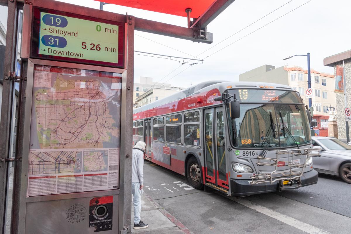
As part of our Next Generation Customer Information System (CIS) project, we are installing over 800 new, larger Liquid Crystal Displays (LCDs) at Muni shelters and stations, replacing existing NextBus signs and expanding real-time information coverage. So far, we are over halfway to completion, with over 435 new displays installed in shelters. New screens show real-time multilingual information including graphics, maps and destinations.

Two displays being shown comparing the old versus new displays

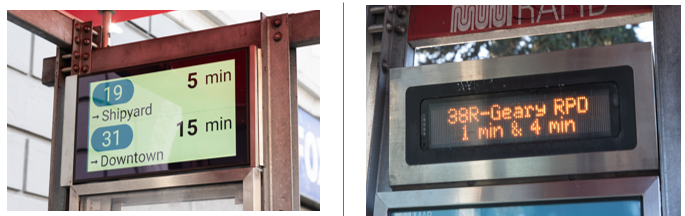
New LCD displays (left) are replacing the previous Muni information displays (right).

Beginning this fall, Muni predictions on our new and improved Next Generation screens will include:

  • Crowding. On vehicles equipped with automatic passenger counters, displays will show how crowded they are.
  • Short-term route changes. We’ll be able to show planned short-term route changes, such as routing around special events. 

We are aiming to replace the remaining displays by the end of 2023. Additionally, we are working on new display locations with an emphasis on underserved neighborhoods, such as those identified by the Bayview Community Based Transportation Plan.

Learn more about the remaining display installation work, what’s next for our Next Generation upgrades and the many new features rolling out soon.

Get Real-Time Stop Information When Predictions Are Unavailable

Due to the nationwide AT&T 3G shutdown on June 8, NextMuni displays that use 3G modems no longer show information. We have been upgrading to 4G modems to continue to provide predictions while we roll out the new LCD display and prepare more significant system software upgrades.

For display locations remain impacted by the 3G shutdown, riders can obtain real-time stop information by using the stop ID number posted at the bus stop:

  • Online enter SFMTA.com/ followed by the stop ID number (no spaces). The stop at Market and 11th streets with stop ID 13245 can be found atSFMTA.com/13245
  • Text “NextMuni” and the stop ID number to 41411. For the stop at Market and 11th with stop ID 13245, send the text “NextMuni 13245” to 41411.
  • Call 511 and say “Departure Times” and the stop ID. For the stop at Market and 11th with stop ID 13245, say “Departure times 13245.”


Published November 03, 2022 at 03:51AM
https://ift.tt/bC87Sum

Comments

Popular posts from this blog

Women Pioneers at Muni: Adeline Svendsen and Muni’s First Newsletter

Women Pioneers at Muni: Adeline Svendsen and Muni’s First Newsletter By Jeremy Menzies To close out Women’s History Month, here’s a look back at one woman whose work to bring Muni staff together in the late 1940s created a legacy that lives on to this day. Adeline “Addy” Svendsen was founding editor of Muni’s first internal newsletter, “ Trolley Topics .” Adeline Svendsen sits at her desk in the Geneva Carhouse office building in this 1949 shot. Trolley Topics was a new venture when it started in February 1946. As Svendsen wrote in the first issue it was created, “to bring a little fun, a little news, and a lot of good will to all our fellow employees in the Railway.” Just two years prior in 1944, Muni merged with the Market Street Railway Company, expanding the small municipal operation into the largest transit provider in the city with hundreds of employees, vehicles of every shape and size, and dozens of facilities scattered across town. The newsletter was meant to help unite ...

Show HN: StreetComplete, an OpenStreetMap Editor for Humans https://ift.tt/2J8IL02

Show HN: StreetComplete, an OpenStreetMap Editor for Humans StreetComplete is an OpenStreetMap[0] editor directed at people who want to contribute and want to do this using their smartphone, without learning how to edit things[1]. It is available as an Android application. It is intended to be used as one walks, with quests appearing as markers on the map. Selecting a marker allows one to answer a simple question. The answer will be added to the OpenStreetMap database, with app handling selecting objects for editing, transforming answer into OSM tags and making edits. OpenStreetMap account is needed to apply edits, but it is possible to start without it, make some edits and login/register later. Note: I am not the main author, but I am one of the active contributors. Github page is at https://ift.tt/2g8lasH and https://ift.tt/3nR9PzS shows what was recently released. [0]OpenStreetMap is a Wikipedia of maps, available on the open licence. This dataset is already used for many interestin...

Show HN: Launch VM workloads securely and instantaneously, without VMs https://ift.tt/2QwJ1Kd

Show HN: Launch VM workloads securely and instantaneously, without VMs Hello HN! We've been working on a new hypervisor https://kwarantine.xyz that can run strongly isolated containers. This is still a WIP, but we wanted to give the community an idea about our approach, its benefits, and various use cases it unlocks. Today, VMs are used to host containers, and make up for the lack of strong security as well as kernel isolation in containers. This work adds this missing security piece in containers. We plan on launching a free private beta soon. Meanwhile, we'd deeply appreciate any feedback, and happy to answer any questions here or on our slack channel. Thanks! April 29, 2021 at 07:50AM