By Amy Fowler
Geary Boulevard is a critical east-west arterial and one of the busiest bus corridors in North America, connecting downtown San Francisco to the Richmond District. The SFMTA has been busy working on the second phase of planned improvements on Geary, called the Geary Boulevard Improvement Project, to improve Muni’s 38 Geary bus service and address traffic safety between 34th Avenue and Stanyan Street.
The project is building on the success of the Geary Rapid Project, which was recently completed on time and on budget and has already shown promising travel time savings on the eastern half of the Geary corridor.
Last fall, we asked neighbors in the Richmond about their priorities for transit, safety and driving issues on Geary via pop-up events on the corridor and a Virtual Open House. Thanks to input from over 600 community members, the SFMTA has used this feedback to draft the detailed, block-by-block project design.
Now we’re conducting outreach on this detailed proposal, which includes:
-
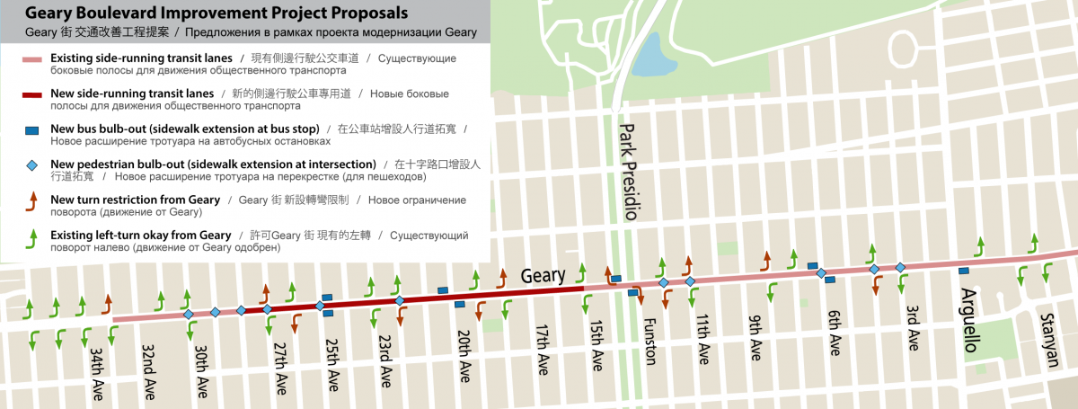
Installing transit lanes between 28th and 15th avenues. To make room, angled parking on Geary would be converted to parallel parking.
-
Relocating 11 bus stops and removing two closely-spaced stops to improve transit performance.
-
Traffic signal upgrades, new bus bulb-outs and lengthening bus zones that are too short to accommodate two buses.
-
Safety improvements, including pedestrian bulb-outs, daylighting, expanded median refuges and left-turn restrictions at key intersections.
Some of the proposed changes would remove parking along Geary—about two parking spaces per block face on average. To help offset this loss, we’re proposing to increase parking spaces on some side streets by converting some parallel parking near Geary to angled parking.
We have also heard from small businesses about the importance of maintaining customer access to their storefronts. In response, we’re proposing parking policy changes that could help increase parking availability for people visiting businesses or other short-term trips. Some of this can be achieved by curb space changes, such as adding more passenger or commercial loading zones. We are also proposing to add evening and Sunday metering on Geary in Central Richmond between 14th and 28th avenues. This would help to improve parking availability for businesses, but would mean free parking at meters wouldn’t start until later in the evening. Parking meters, especially in commercial areas, are the most effective tool we have to manage parking in high-demand areas. The proposed extended hours can help support increased business activity and make parking spaces easier to find for everyone.
Do you live or work in the Richmond near Geary? We want your feedback!
Learn more about the detailed project design and let us know what you think in two simple steps:
Step 1: Visit our website, where you can review the block-by-block design for the Geary Boulevard Improvement Project. Learn about improvements proposed, including additional transit lanes, bus stop changes and safety treatments.
Step 2: Then, take a brief survey about the detailed project design. Let us know which project proposals you like or don’t like. The survey will be open through March 31.
Want to connect directly with staff about the project? You can meet with project staff in-person at our Community Pop-Up event at Geary and 20th Avenue on Tuesday, March 15 from 11:00am to 1:00pm. Or, drop in to our Virtual Office Hours on Wednesday, March 16, anytime from 5:30 p.m. to 7 p.m.
We’ll also be hosting a self-guided (unstaffed) open house at One Richmond (802 Clement Street at 9th Avenue). Drop in anytime Mondays – Fridays from 1-5 p.m. through March 28 to view project materials and take the survey in-person.
We’ll use this input to help create the final project proposal, to be considered for approval later in 2022 by the SFMTA Board of Directors. Construction would be coordinated with needed utility upgrades, as many sewer and water pipes under Geary are over 100 years old.
Learn more about the project at SFMTA.com/ImproveGeary.
Published March 11, 2022 at 12:40AM
https://ift.tt/yJ68aOh
Comments